mistercanoehead header & home page link

MISSISSAGI RIVER 2007

We had considered several other routes for this year's trip, but settled on this one because of its variety of challenges and types of water. The trip was to be fairly relaxed in terms of time. We were here in 1999 and had, generally, a good trip.


After approximately 10 hours on the road, we arrived at the Aubrey Falls Trading Post. Mike and Jackie made us feel comfortable for the night and Mike ferried us up to our start point on the Mississagi River at Spanish Chutes, with the agreement to leave our vehicle at the road into the Rocky Island Lake Dam, a popular crown land spot for fishermen.

Aubrey Falls Trading Post (Hwy 129, north of Thessalon/Iron Bridge) is under new management. They are trying to regain a foothold in the canoeing, fishing & hunting needs of the area.
In addition to the set up/shuttle of trips, etc., they have a full service motel and restaurant. We found them to be very accommodating to our needs. They had a good knowledge of the variety of possiblities that were available in the area. They certainly treated us well!


We were concerned about the possibility of water level fluctuations due to hydro demand in the hot weather which was forecast over the next couple of weeks.
There are several alternates for pull outs along Rocky Island Lake.
  • Aubrey Falls Dam, which was the least favourable option due to the distance over a potentially windy lake and a 720m portage to get from one bit of big water to another.
  • Rocky Island Lake Dam location, but it was gated.
  • Rouelle Landing on the north shore was briefly considered, but due to the midweek finish and possibility of the Peshu Road being poor as an access, that option was shelved.
  • We settled on an access used by fishermen on the south shore at the end of a branch of the Rocky Island Lake dam road. It was easy to get to and only a few minutes away from the Aubrey Falls Trading Post, so leaving our vehicle at the pull out was convenient for them.
Over the next 9 days, we traversed a variety of environments which went from small streams to marsh and big lakes. The weather was hot and, at times, muggy. The only rain that we got was as we pulled out on the south shore of Rocky Island Lake, a couple of kilometres south of the Rocky Island Lake Dam.

We met no other canoers (ists) over the time that we were on the water but did stop for a chat with Jack, who owned the private family 'resort' on Upper Green Lake. This was at the original location of a Northwest Company Outpost. As well, we talked to a couple of fishermen from Ohio. They were staying at a fly-in outpost on Kettle Lake.


The Aubrey Falls dam produces electricity for OPG, etc. by holding back Aubrey and Rocky Island Lake through an associated set of dams. This determines to some degree the water levels in the lower section of the Mississagi River.


We put in at Spanish Chutes at noon on July 22 (Sunday) and decided to make it an easy day.
The weather looked as if it would continue to be great for a while.


The 500m portage into Spanish Lake was wet at the start and had a large wet area at the end over which we used the canoe to ferry the gear and us.


We had heard that Spanish Lake had some good island campsites. The island site that we chose was very nice!


At this point in the trip, we were going 'upstream'. Both Spanish and Bardney Lakes drain into the Spanish River system.


Repairs had been done on the concrete since 1999.


The 500m portage over the watershed into Sulphur Lake and the Mississagi system is a long, steady climb. The 1000m portage was very buggy and, in the heat, hard. Thrown in among these two brutes are a 200m and a couple of 90m walks, just for kicks.
We were thankful when this series of portages ended. They are the toughest on the trip. It is worth assuming, depending on weather that about half a day will be spent doing this bit.

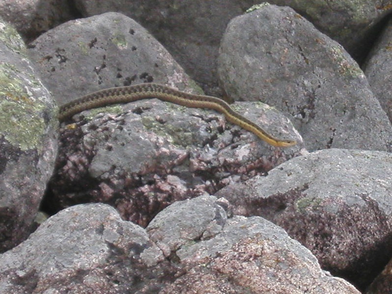
The only wildlife we saw on this stretch was a snake.

At the end of the portage out of Shanguish Lake, we stopped to fish. Results: 4 small pike.
We set up camp on a peninsula at the North end of Limit Lake.


This was a 'laundry day'. After finding a good campsite on Upper Bark lake, we got off the water fairly early and tended to the domestic stuff. Besides, the temperature had climbed to a point where we decided a bit of shade would prepare us for the next leg of the trip.


We decided to forgo the two portages that cut across from Upper Bark Lake to Bark lake. Instead, we did the 'long way round'. This quiet, colourful stretch of the river took us longer, but was worth it.


The legendary Grey Owl (Archie Belaney) lived in this cabin. Although he was not a native, he lived as one and wrote about his wilderness life. It is unfortunate that his dwelling has been defaced by hundreds of people over the years. The earliest initial carvings that we saw was in the 1940s.


The current owner could do more than put up 'private property' signs. A carving board, for those who must, could be erected away from the cabin. As well, Grey Owl is an icon of our wilderness heritage and as such should be better honoured by keeping the cabin in better condition.


Even if the cabin sits on private property, it is in the middle of a Provincial Park whose managers could make some arrangement to preserve it.


When we pulled in at the Grey Owl cabin, we set up camp behind the outfitters cabin. It was a nice, flat spot with relatively few bugs.


Split Rock Rapids/Falls is runnable with a bit of care.


Keeping to the right side of the visible rock involves a bit of a drop, but with enough water, it is doable. Going on the left side is not advisable due to the hidden rocks.


An upstream view. Not the best light conditions.


Hanging the food over the cliff edge was easy. Any animal trying to get at it from the ground would have a lot of difficulty!


The camp at Split Rock was elevated and relatively bug free.


It had a nice view downstream.


Although free of black flies & mosquitoes, we used a bug hat to keep other types of flies at bay while the baked bannock bread cooled.


This section of the river is typical of the 'pool & drop' topography. The approach to Hellgate is calm and slow.


About half way across the portage, near the log box, the light was just right for this shot of a spider web. Five minutes later, the light was gone.


Hellgate starts out as a series of steps . . . then drops.


The falls is approximately 6 m high. This is a definite Do Not Run section!


We made camp further downriver from Hellgate and were visited by several Fritillaries, one of which was rather friendly.


Taking the comforts of home can include a table. This one is built so that it can be dismantled and rolled.
It weighs very little.


As we approached the marsh, the outcrops receded and our line of sight increased substantially. We watched an immature eagle (eaglet) for a while in a nest high in an old white pine tree.


The current that took us through the marsh was actually pretty good. On a number of occasions, we doubled back on the route due to 'oxbows' in the main channel.


Our weather luck continued. We left camp at 7:00 am due to a rain front moving in. Several of these frame structures can be found on Rocky Island Lake. Our assumption is that tarps are laid across the frames.


Evidently they are used on a routine basis by fisherman. The sites were fairly well appointed with counter-tops, benches and rugs (!!??).


On one of our 'GOAAS' (GO Ashore And Stretch) breaks, we stopped at a rocky bit just barely above water.


The rocks showed evidence of both wave weathering and ice shatter in the layers.


There were a number of places along the shore where cliffs plunged into the water.


At our last camp on the east end of Rocky Island Lake, we enjoyed a bug reduced, warm night.
The campsite was a well used fisherman's stop with a table and frame for a tarp.
This reflective, panoramic south view of the inlet into Rocky Island Lake taken at about 8:00 pm pretty well sums up our trip.
Bright, hot and dry.